
Class 6 Social Science Chapter 1 Locating Places on the Earth Questions Answers
Class 6 Social Science Chapter 1 Locating Places on the Earth Questions Answers provide you with in-depth answers to all the questions given in the Chapter 1 Locating Places on the Earth. These questions answers will provide you with knowledge of all the essential topics covered in the chapter. This chapter covers topics like maps, elements of maps, coordinates, latitudes, and longitudes. The chapter helps in finding and identifying the places on Earth using latitudes and longitudes.
Locating Places on the Earth Chapter 1 Questions Answers PDF provides you with solutions to the chapter in a simplified manner and helps students develop a keen understanding of the chapter. Students are advised to explore and practise the chapter multiple times to consolidate the learning of the chapter.
Download Class 6 Social Science Chapter 1 Locating Places on the Earth Questions Answers PDF
The Big Questions (Page 7)
1. What is a map, and how do we use it? What are its main components?
Answer:
A map is a visual representation or a drawing of an area drawn on a flat surface according to a scale. It can be used to represent a small area (a village, a town, etc.), a bigger area (a district or a state), or a very large area like India or even the whole world. The main components of the maps are distance, directions, and symbols.
2. What are coordinates? How can latitude and longitude be used to mark any location on Earth?
Answer:
A set of values or items used to indicate the exact position of a place or an object are known as coordinates. For instance, latitude and longitude are two coordinates used to mark the location of a place on Earth. Latitude measures the distance of a place north or south of the equator, ranging from 0° at the equator to 90° at the poles, and longitude measures the distance of a place east or west of the Prime Meridian, ranging from 0° to 180° east and 0° to 180° west.
3. How are local time and standard time related to longitude?
Answer:
Local time is determined by the position of the Sun in the sky at a particular longitude, so places along the same longitude generally share the same local time.
However, in regions that span multiple longitudes, standard time is used. Standard time is a uniform time observed across a specific region or time zone and is typically based on the local time at the region’s central meridian.
Let’s Explore (Page 9)
1. On the map in Fig. 1.1 given on page 8 —
(i) Mark the hospital.
(ii) What is the meaning of the blue-coloured areas?
(iii) Which is farther away from the railway station — the school, the Nagar Panchayat, or the public garden?
Answer:
(i)
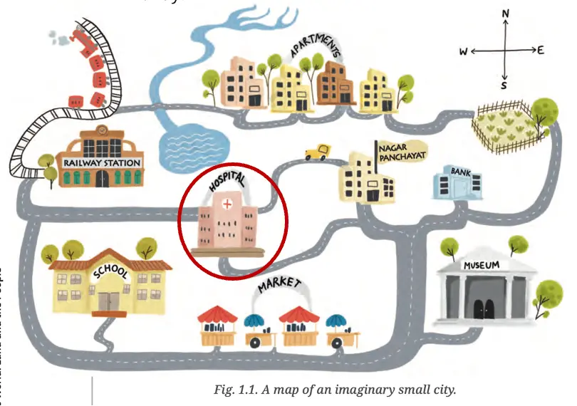
(ii) The blue color areas represent water bodies.
(iii) The public garden.
2. As a class activity, form groups of three or four students each. Let each group try to draw a map of your school and some of the streets or roads that lead to it, and a few neighbouring buildings. At the end, compare all the maps and discuss.
Answer:
Do it yourself.
Let’s Explore (Page 10)
1. Draw a simple map of a school’s playground. Let us assume it is a rectangle, 40 m in length and 30 m in width. Draw it precisely with your ruler on a scale of 1 cm = 10 m.
Answer:
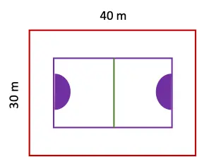
2. Now measure the diagonal of the rectangle. How many centimetres do you get? Using the scale, calculate the real length of the playground’s diagonal, in metres.
Answer:
Length of the playground’s diagonal on the map = 5 cm.
Actual length of the playground’s diagonal on the ground = 5×10 = 50 m.
Let’s Explore (Page 11)
1. Consider the map of the small city again. Identify the correct and incorrect statements in the list below:
(i) The market is north of the hospital.
(ii) The museum is southeast of the bank.
(iii) The railway station is northwest of the hospital.
(iv) The lake is northwest of the apartment blocks.
Answer:
(i) Incorrect.
(ii) Correct.
(iii) Correct.
(iv) Incorrect.
2. Taking your school as the starting point, do you know approximately in which cardinal direction your home is located? Discuss with your teacher and your parents.
Answer:
My home is located southeast of my school.
Let’s Explore (Page 11)
1. Draw a rough map of your locality or your village, including your home, school, and a few other important landmarks. Show the cardinal directions and use a few of the symbols shown in Fig. 1.2 on page 12 to mark some important features.
Answer:
Do it yourself
Let’s Explore (Page 13)
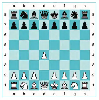
1. Using the same terms, write down your move if you play black and respond with the same move.
Answer:
I will move the pawn from g7 to g5.
Let’s Explore (Page 17)
1. If the globe or atlas in your class has well-marked latitudes and longitudes, try to note down approximate values for the latitude and longitude of (1) Mumbai, (2) Kolkata, (3) Singapore, (4) Paris.
Answer:
(1) Mumbai – Latitude: 19.0760° N and Longitude: 72.8777° E.
(2) Kolkata – Latitude: 22.5726° N and Longitude: 88.3639° E.
(3) Singapore – Latitude: 1.3521° N and Longitude: 103.8198° E.
(4) Paris – Latitude: 48.8566° N and Longitude: 2.3522° E.
Let’s Explore (Page 21)
1. Two friends, one sitting in Porbandar (Gujarat) and the other in Tinsukia (Assam), are speaking on the phone late afternoon. The latter remarks that the sun has set in Assam and it’s now dark. The former is surprised and says, “But it’s still full daylight here!” Explain why. And, as a class activity, calculate the difference in local time between those two cities. (Hint: for now, consider the difference in longitude between Porbandar and Tinsukia to be 30°; later, you can find out the precise value.)
Answer:
The sun sets earlier in Assam than in Porbandar because of the difference in local time between the two places situated at different longitudes. Since the Earth rotates from west to east, places located farther east experience sunrise (and sunset) earlier than those in the west.
Degrees completed by the Earth in one full rotation (24 hours) = 360°.
Degrees completed by the Earth in 1 hour = 360°/ 24 = 15°.
Time taken by the Earth to rotate 15° = 60 minutes (1 hour).
Time taken by the Earth to rotate 1° = 60/15 = 4 minutes.
Longitudinal difference between Porbandar and Tinsukia = 30°
Therefore, the difference in local time between two places = 30 × 4 = 120 minutes or 2 hours.
Let’s Explore (Page 21)
1. Return to the two friends sitting in Gujarat and Assam. Use this example to explain the difference between local time and standard time.
Answer:
Since Gujarat lies 30° west of Assam, two friends sitting in Gujarat and Assam would notice a time difference of about 2 hours if they looked at the sun to tell the time. This is due to the difference in local time between places located on different longitudes.
However, if they checked their watches, they would see the same time. That’s because India uses a standard time based on the 82.5°E meridian, which passes near Mirzapur in Uttar Pradesh. This is called Indian Standard Time (IST) and is used across the entire country to avoid confusion caused by different local times.
Questions, Activities, and Projects (Page 24)
1. Returning to page 10 and to Fig. 5.2 in Chapter 5 of this textbook, taking the scale to be 2.5 cm = 500 km, calculate the real distance from the estuary of the Narmada River to the estuary of the Ganga River. (Hint: round off your measurement on the map to an easy number.)
Answer:
Distance between the estuary of the Narmada River to the estuary of the Ganga River represented on the map = 10 cm
Actual distance between the two places on the ground = Measured distance in cm / Scale in cm × Real distance in km
= 10/2.5 × 500
= 4 × 500
= 2000 km.
2. Why is it 5:30 pm in India when it is 12 pm or noon in London?
Answer:
India, located at 82.5° East longitude, lies to the east of the Prime Meridian in Greenwich (London). Indian Standard Time (IST) is based on this longitude and is 5 hours and 30 minutes ahead of Greenwich Mean Time (GMT). Therefore, when it is 12 pm in London, it is 5:30 pm in India.
3. Why do we need symbols and colours in the map?
Answer:
Symbols and colours help represent features like buildings, roads, bridges, forests, railway lines, and water bodies effectively on a map. They convey a lot of information in a limited space, making the map easier to draw and simpler to read.
4. Find out what you have in the eight directions from your home or school.
Answer:
Directions from my home:
North: Residential houses
North-west: School
North-east: Tube well
East: College
West: Tube well
South-west: Banquet Resort
South-east: Agricultural lands
South: Power station
5. What is the difference between local time and standard time? Discuss it in groups, with each group writing an answer in 100 to 150 words. Compare the answers.
Answer:
Local time refers to the time of a place based on the position of the Sun in the sky at a particular longitude. When the Sun is at its highest point at the Prime Meridian in Greenwich, all places along this meridian experience midday. As the Earth rotates from west to east, places lying east of Greenwich are ahead of Greenwich Mean Time (GMT), while those to the west are behind it.
For a country spanning multiple longitudes, it is quite inconvenient to use many local times. To overcome this, the local time of a central meridian is taken as the standard time for the whole country. In India, the longitude 82.5°E is taken as the Standard Meridian, and the local time at this meridian is observed as the Indian Standard Time (IST) across the entire nation.
6. Delhi’s and Bengaluru’s latitudes are 29°N and 13°N; their longitudes are almost the same, 77°E. How much will be the difference in local time between the two cities?
Answer:
Longitudes help us determine the local time of a place, and places lying on different meridians have different local times. Since Delhi and Bengaluru are located on nearly the same longitude, they will have the same local time.
7. Mark the following statements as true or false; explain your answers with a sentence or two.
(i) All parallels of latitude have the same length.
(ii) The length of a meridian of longitude is half that of the Equator.
(iii) The South Pole has a latitude of 90°S.
(iv) In Assam, the local time and the IST are identical.
(v) Lines separating the time zones are identical with meridians of longitude.
(vi) The Equator is also a parallel of latitude.
Answer:
(i) False.
Explanation – The Equator is the longest line of latitude, and the lengths of latitudes decrease as we move away from the Equator toward the poles.
(ii) True.
Explanation: The Equator is the longest horizontal circle around the Earth, while meridians are vertical half-circles that connect the North and South Poles. This makes them half the length of the Equator.
(iii) True.
Explanation: The South Pole lies at 90° south of the equator.
(iv) False.
Explanation: IST remains the same throughout the country, while the local time in Assam depends on the longitude passing through it.
(v) False.
Explanation: The lines dividing time zones are often adjusted for political reasons and do not follow straight meridians of longitude.
(vi) True.
Explanation: The Equator is the longest parallel of latitude, located at 0°, and it divides the Earth into the Northern and Southern Hemispheres.
8. Solve the crossword below.
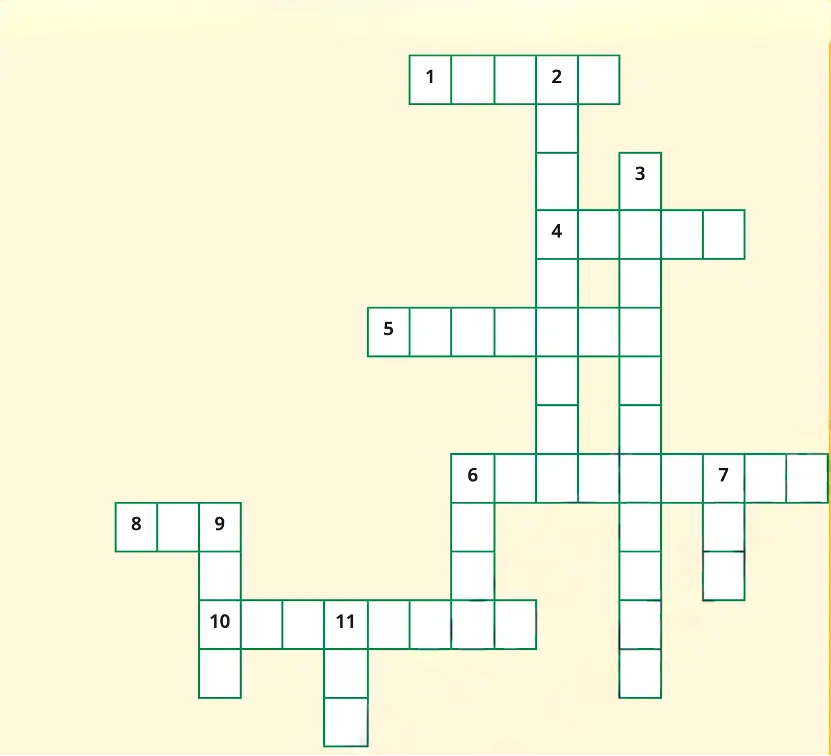
Across | Down |
1. Let’s you squeeze a huge area into your map | 2. A measure of the distance from the Prime Meridian |
4. A convenient sphere | 3. These two together allow us to locate a place |
5. The longest parallel of latitude | 6. What latitudes and longitudes together create |
6. The place the Prime Meridian is attached to | 7. The time we all follow in India |
8. So convenient to find your way | 9. On top of the world |
10. A measure of the distance from the Equator | 11. An abbreviation for a line across which the day and date change |
Answer:
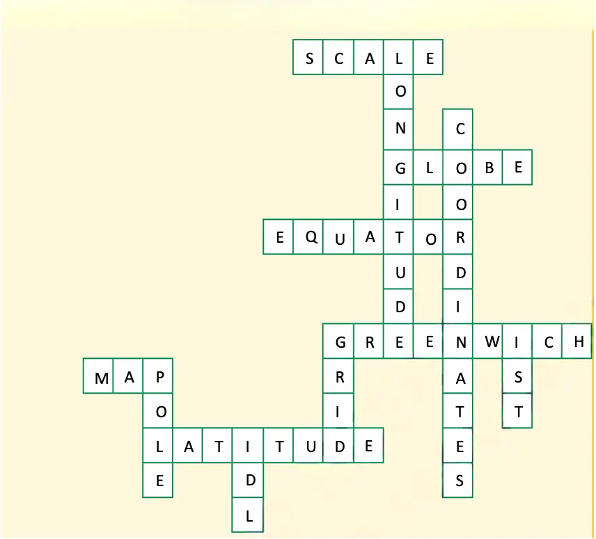
Across | Down |
1. Let’s you squeeze a huge area into your map – Scale. | 2. A measure of the distance from the Prime Meridian – Longitude |
4. A convenient sphere – Globe | 3. These two together allow us to locate a place – Coordinates |
5. The longest parallel of latitude – Equator | 6. What latitudes and longitudes together create – Grid |
6. The place the Prime Meridian is attached to – Greenwich | 7. The time we all follow in India – IST |
8. So convenient to find your way – Map | 9. On top of the world – Pole |
10. A measure of the distance from the Equator – Latitude | 11. An abbreviation for a line across which the day and date change – IDL |